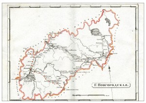
How do you imagine what a road was, historically? Quite often, histories of transport describe histories of surfaces: the evolution of building techniques, say, from wooden planks to macadamized stone to modern asphalt or concrete.

Alternatively, roads are presented as transportation networks or ‘scapes’: that is, as a series of junctures (like the famous Moscow Metro Map) that permit traffic to flow from stop to stop to stop. Yet however important construction- or traffic-based approaches are, one thing they don’t capture is the way that human community is arranged in support of roads, and why. What are the social ‘moorings’ that sustain roads: that service their surfaces and also their travelers, and thereby make transportation along their elaborately constructed landscapes possible at all?
I’ve been trying to visualize an answer to this question, for one of Russia’s most famous roads: the Petersburg-Moscow corridor, in the late 18th century. In what follows, I sketch some initial results; I’d be happy for your thoughts on it.